Researchers) IMAMOGLU Nevrez, Senior Researcher, CAGLAYAN Ali, Senior Researcher, KOUYAMA Toru, Group Leader, TSUTSUMI Chiaki, Principal Research Manager, Intelligent Platforms Research Institute
- AIST's ABCI large-scale AI cloud computing system enables training of a foundation model using large-scale SAR observation data from JAXA's DAICHI-2 (ALOS-2) satellite
- SAR foundation model specific to Japanese land area is developed using a training dataset constructed by minimizing land use and land cover bias.
- By using foundation models to reduce the difficulty of interpreting SAR images which typically requires specialized knowledge, the applications of SAR imagery are expected to broaden.
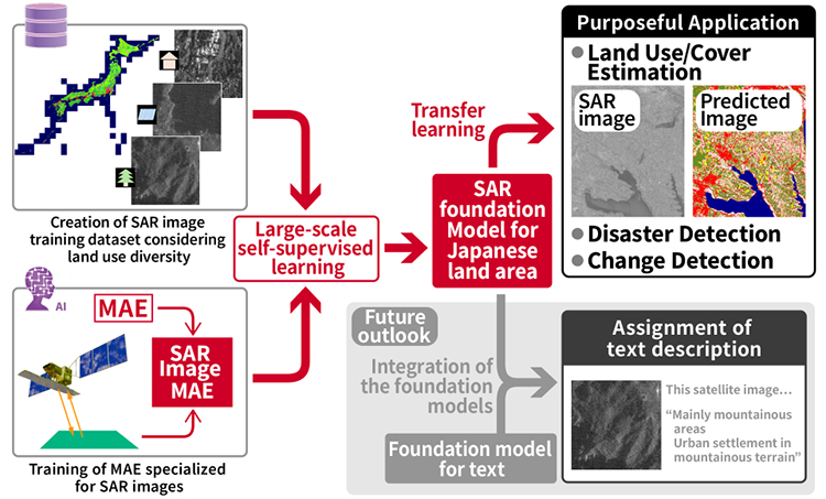
Construction and anticipated applications of a national land-specific SAR foundation model. The high-resolution land use and land cover map of Japan, used in this work, was provided by JAXA.
Researchers at AIST, in collaboration with JAXA, have developed a national land-specific Synthetic Aperture Radar (SAR) foundation model using high-resolution observation SAR data routinely acquired over Japan by the SAR instrument, PALSAR-2, onboard the "DAICHI-2" (ALOS-2).
The PALSAR-2 observation data covers the entire country, and by extracting image patches centered on selected locations, a training dataset reflecting diverse land use and land cover types was constructed. Using this dataset, we performed large-scale self-supervised learning to build a SAR foundation model specialized for Japan’s land area. The results from transfer learning for land use/land cover estimation showed significantly higher accuracy compared to models trained from scratch, demonstrating the effectiveness of the foundation model trained on a more balanced dataset. Although the foundation model is initially developed by researchers at AIST and JAXA, it is expected to broaden the use of SAR by utilizing the foundation model that can reduce both the cost of model development and the barrier to interpreting SAR images, which typically requires specialized expertise.
This research was conducted based on the "Agreement on Research and Development of AI Analysis Methods for Satellite Data" between AIST and JAXA, and AIST policy-based budget project "R&D on Generative AI Foundation Models for the Physical Domain". We used ABCI 3.0 provided by AIST and AIST Solutions with support from “ABCI 3.0 Development Acceleration Use”. The details of the research results were presented at the 78th Annual Conference of the Remote Sensing Society of Japan (Spring 2025) held from June 4 to June 5, 2025.
SAR is a microwave-based remote sensing technology that uses synthetic aperture techniques from satellites and aircraft to capture high resolution land surface images in both day and night and in any weather conditions. PALSAR-2, onboard JAXA's satellite "DAICHI-2" (ALOS-2) is an L band SAR, and continuously observes regions around the world, including Japan, regardless of time and weather.
However, expanding the use of SAR to a wider range of fields has a key challenge: interpreting SAR data requires specialized knowledge, and training AI models for this task demands large-scale computation and access to extensive data, which can be costly. Foundation models offer a potential solution. While their construction requires significant data and computational resources, once trained, they can serve as a general base for building specialized AI models that require only minimal fine-tuning for specific tasks.
Conference name: The 78th (2025 Spring) Annual Conference of the Remote Sensing Society of Japan
Title: Self-Supervised Pre-Training and Image Segmentation Task on ALOS2 Single-Channel SAR Images
Author: Nevrez Imamoglu, Ali Caglayan, Toru Kouyama